
Cape Town and the Garden Route
South Africa
Overview
Explore Cape Town, then wind your way along the “garden route”, experiencing South Africa’s wild coast.
Cape Town
Cape Town (Afrikaans: Kaapstad; [ˈkɑːpstat], Xhosa: iKapa) is one of South Africa's three capital cities, serving as the seat of the Parliament of South Africa. It is the legislative capital of the country, the oldest city in the country, and the second largest (after Johannesburg). Colloquially named the Mother City,it is the largest city of the Western Cape province, and is managed by the City of Cape Town metropolitan municipality. The other two capitals are Pretoria, the executive capital, located in Gauteng, where the Presidency is based, and Bloemfontein, the judicial capital in the Free State, where the Supreme Court of Appeal is located. Cape Town is ranked as a Beta world city by the Globalization and World Cities Research Network.The city is known for its harbour, for its natural setting in the Cape Floristic Region, and for landmarks such as Table Mountain and Cape Point. Cape Town is home to 66% of the Western Cape's population. In 2014, Cape Town was named the best place in the world to visit by both The New York Timesand The Daily Telegraph. Located on the shore of Table Bay, the City Bowl area of Cape Town, is the oldest urban area in the Western Cape, with a significant cultural heritage. It was founded by the Dutch East India Company (VOC) as a supply station for Dutch ships sailing to East Africa, India, and the Far East. Jan van Riebeeck's arrival on 6 April 1652 established the VOC Cape Colony, the first permanent European settlement in South Africa. Cape Town outgrew its original purpose as the first European outpost at the Castle of Good Hope, becoming the economic and cultural hub of the Cape Colony. Until the Witwatersrand Gold Rush and the development of Johannesburg, Cape Town was the largest city in southern Africa.
Cape of Good Hope
The Cape of Good Hope (Afrikaans: Kaap die Goeie Hoop [ˌkɑːp di ˌχujə ˈɦuəp])[a] is a rocky headland on the Atlantic coast of the Cape Peninsula in South Africa. A common misconception is that the Cape of Good Hope is the southern tip of Africa, based on the misbelief that the Cape was the dividing point between the Atlantic and Indian oceans. In fact, the southernmost point of Africa is Cape Agulhas about 150 kilometres (90 mi) to the east-southeast. The currents of the two oceans meet at the point where the warm-water Agulhas current meets the cold-water Benguela current and turns back on itself. That oceanic meeting point fluctuates between Cape Agulhas and Cape Point (about 1.2 kilometres (0.75 mi) east of the Cape of Good Hope). [Interactive fullscreen map] The Cape of Good Hope at the southern tip of the Cape Peninsula, approximately 50 km (31 mi) south of Cape Town, South Africa. Cape Agulhas is the southernmost part of South Africa. When following the western side of the African coastline from the equator, however, the Cape of Good Hope marks the point where a ship begins to travel more eastward than southward. Thus, the first modern rounding of the cape in 1488 by Portuguese explorer Bartolomeu Dias was a milestone in the attempts by the Portuguese to establish direct trade relations with the Far East (although Herodotus mentioned a claim that the Phoenicians had done so far earlier).Dias called the cape Cabo das Tormentas ("Cape of Storms"; Dutch: Stormkaap), which was the original name of the "Cape of Good Hope".As one of the great capes of the South Atlantic Ocean, the Cape of Good Hope has long been of special significance to sailors, many of whom refer to it simply as "the Cape". It is a waypoint on the Cape Route and the clipper route followed by clipper ships to the Far East and Australia, and still followed by several offshore yacht races.
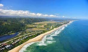
Garden Route
The Garden Route (Afrikaans: Tuinroete) is a 300-kilometre (190 mi) stretch of the south-eastern coast of South Africa which extends from Witsand in the Western Cape to the border of Tsitsikamma Storms River in the Eastern Cape. The name comes from the verdant and ecologically diverse vegetation encountered here and the numerous estuaries and lakes dotted along the coast. It includes towns such as Knysna, Plettenberg Bay, Mossel Bay, Great Brak River, Little Brak River, Wilderness, Sedgefield and Nature's Valley; with George, the Garden Route's largest city and main administrative centre. It has an oceanic climate, with mild to warm summers, and mild to cool winters. Temperatures rarely fall below 10 °C in winter and rarely climb beyond 28 °C in summer. Rain occurs year-round, with a slight peak in the spring months, brought by the humid sea-winds from the Indian Ocean rising and releasing their precipitation along the Outeniqua and Tsitsikamma Mountains just inland of the coast. The Route is sandwiched between the aforementioned mountains and the Indian Ocean, with mountain passes, including the Outeniqua Pass, linking the area with the arid Little Karoo. The Outeniqua and Tsitsikamma indigenous forests are a unique mixture of Cape Fynbos and Temperate Forest and offer hiking trails and eco-tourism activities. Nearly 300 species of birdlife are to be found in a variety of habitats ranging from fynbos to forest to wetlands. In 2017 the Garden Route was added to UNESCO's World Network of Biosphere Reserves.
Port Elizabeth
Port Elizabeth, officially renamed Gqeberha (Xhosa: [ᶢǃʱɛ̀ɓéːxà]) and colloquially often referred to as P.E.,[a] is a major seaport and the most populous city in the Eastern Cape province of South Africa. It is the seat of the Nelson Mandela Bay Metropolitan Municipality, South Africa's second-largest metropolitan district by area size. It is the sixth-most-populous city in South Africaand is the cultural, economic and financial centre of the Eastern Cape. The city was founded as "Port Elizabeth" in 1820 by the government of the Cape Colony when 4,000 British colonists settled Algoa Bay to strengthen the border region between the Cape Colony and the Xhosa. It is nicknamed "The Friendly City" or "The Windy City". In 2019, the Eastern Cape Geographical Names Committee recommended that Port Elizabeth be renamed Gqeberha, after the Xhosa and Southern Khoe name for the Baakens River that flows through the city. The city's name change was officially gazetted on 23 February 2021. Located on the western portion of Algoa Bay along the southeastern coast of South Africa, the city lies 770 km east of Cape Town. It is east of the Garden Route and faces the Indian Ocean. It covers 251 square kilometers of the Nelson Mandela Bay metropolitan area, South Africa's sixth-largest metropolitan municipality. The city's warm oceanic climate ranks it among the top cities in the world for pleasant year-round weather. The city is known for many blue-flag beaches along the city's urban coastline; its popularity as an international and local holiday destination; and its rich and diverse cultural heritage. It is a gateway city for the Eastern Cape's adventure, outdoor and African big five game safari tourism